Deir al-Munira
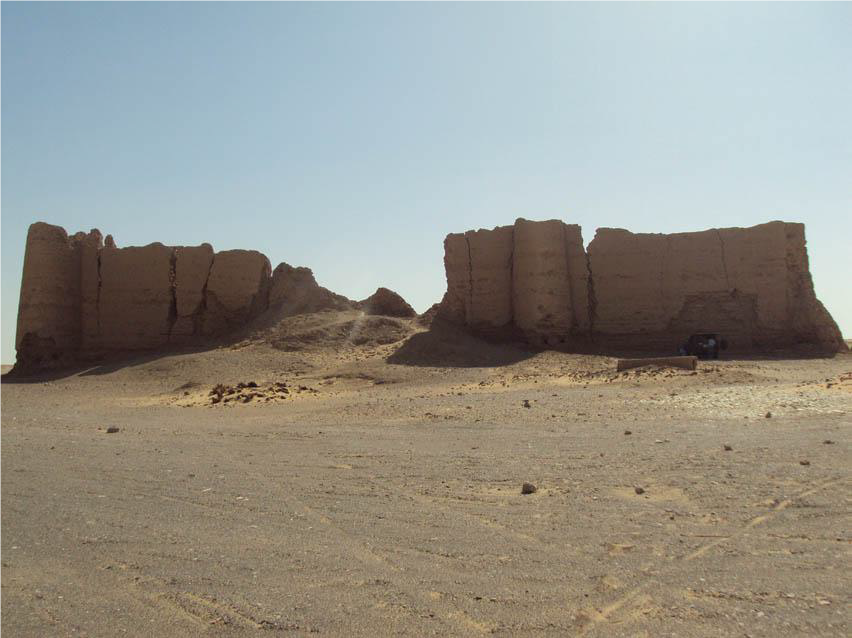
The town at al-Deir (or Deir al-Munira) was probably occupied from the 4th century BC to the 6th century AD. Today there are the remains of a fortress. Deir al-Muniralies at the foot of the eastern escarpment about 20 km north of el-Kharga, where it guarded the main desert route towards Farshut and the Nile Valley. A well-defined dirt track to the fortress of el-Deir leads off from the main Kharga to Assyut road but ends about two kilometres from the site. The last part over a chain of encroaching sand dunes should not be attempted unless on foot or alternatively from the south in a 4×4 vehicle. Permission from the Antiquities Office and a guide must be obtained before visiting this site. The current brick fortress probably dates to the reign of Diocletian (AD 284-305). It has twelve round towers, two in each of the four sides and one in each corner. Inside are several rooms with wonderful graffiti, most written by soldiers who were stationed in the Western Desert. There are drawings of Turkish soldiers with tarbushes (hats), airplanes and tanks from British regiments, and many names in Arabic, Coptic, Turkish and English. In the courtyard of the fortress there is a large well which is now filled with sand. Water was led from the well through an underground aqueduct system to the fields outside the fortress walls. After the decline of the Romans the site may have been used as a Christian monastery, which would account for the name El Deir. About 1.5 km northwest of the fortress is a mudbrick temple from the 2nd-3rd centuries containing four chambers. It was later converted to a church. This church may have been part of the deir (monastery) that the name of the site refers to. Around the temple are remains of the town, including many visible traces of the ancient irrigation system. Around the Roman fortress there is also a necropolis investigated by a French team since 1997. In the southern part are tombs with remains in wooden sarcophagi. In the north they found tombs with limestone sarcophagi, some with well-preserved mummies still inside. These tombs probably date to the late Roman period (3rd-5th centuries AD). In the east were Ptolemaic tombs reused for the burial of mummified dogs. In the west there are also Christian burials from around the 4th and 5th centuries. At the west of the fortress there are also the remains of an embalming house of mudbrick. Vases found inside the house contained products used in embalming, such as oil and natrium (CISS Inventory 2010; Vivian 1990).
Site coordinates: N 25 35 492 E 30 43 503